Bathymetric surveys in shallow water play a critical role in understanding underwater topography where traditional deep-water survey methods often fail. These surveys provide precise depth measurements and seabed mapping in areas such as rivers, lakes, coastal zones, harbors, and nearshore regions. Because shallow waters are dynamic and sensitive environments, accurate bathymetric data is essential for safe navigation, infrastructure planning, environmental protection, and resource management.
With advancements in survey technologies, bathymetric surveys in shallow water have become more efficient, accurate, and accessible than ever before.
What Are Bathymetric Surveys in Shallow Water?
Bathymetric surveys in shallow water involve measuring the depth and shape of underwater surfaces in areas where water depths are limited, often ranging from a few centimeters to several meters. Unlike deep-sea surveys, shallow-water bathymetry must account for obstacles such as vegetation, sediment movement, waves, and restricted access.
The goal is to create detailed maps or digital models of the seabed that support engineering, environmental, and navigational decision-making.
Why Bathymetric Surveys in Shallow Water Are Important?
Shallow-water environments are some of the most active and economically valuable regions on Earth. Accurate bathymetric surveys in shallow water are essential for:
- Navigation safety in ports, marinas, and inland waterways
- Coastal and river engineering projects
- Flood risk assessment and water management
- Environmental monitoring and habitat mapping
- Dredging planning and sediment analysis
Even minor depth inaccuracies in shallow areas can lead to vessel grounding, structural damage, or environmental harm.
Common Methods Used in Shallow Water Bathymetric Surveys
Single-Beam Echo Sounders
Single-beam systems emit sound waves directly beneath the survey vessel and measure depth from the returning signal. They are cost-effective and suitable for small-scale shallow-water projects.
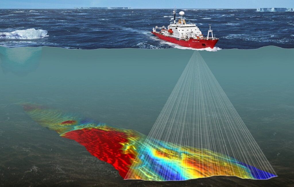
Multi-Beam Echo Sounders
Multi-beam systems capture wide swaths of seabed data, providing high-resolution 3D maps. Although more complex, they offer exceptional accuracy for detailed shallow-water bathymetric surveys.
LiDAR Bathymetry
Airborne LiDAR uses laser pulses to measure depths in clear, shallow waters. This method is ideal for coastal zones where vessels cannot operate safely.
Uncrewed Surface Vehicles (USVs)
Autonomous and remotely operated survey vessels are increasingly used for bathymetric surveys in shallow water due to their ability to access narrow or hazardous areas safely.
Challenges in Bathymetric Surveys in Shallow Water
Despite technological advancements, shallow-water surveying presents unique challenges:
- Wave action and tides affecting accuracy
- Water turbidity reducing signal penetration
- Submerged vegetation and debris
- Limited vessel maneuverability
- Rapid seabed changes due to sediment movement
Surveyors must carefully select equipment and apply corrections to ensure reliable results.
Applications of Bathymetric Surveys in Shallow Water
Coastal Development
Bathymetric surveys in shallow water support the design of seawalls, ports, bridges, and offshore structures by providing accurate seabed data.
Environmental and Marine Studies
These surveys help monitor coral reefs, wetlands, riverbeds, and aquatic habitats, aiding conservation efforts and environmental impact assessments.
Flood and Drainage Management
Accurate depth data improves hydraulic modeling, helping authorities predict flooding and manage water resources effectively.
Dredging and Maintenance
Ports and waterways rely on shallow-water bathymetric surveys to plan dredging operations and maintain safe navigation depths.
Benefits of Accurate Shallow Water Bathymetry
- Improved project planning and cost control
- Enhanced navigational safety
- Reduced environmental risks
- Better long-term coastal and waterway management
- High-resolution data for decision-making
- Investing in professional bathymetric surveys in shallow water prevents costly errors.
- Future Trends in Shallow Water Bathymetric Surveys
The future of bathymetric surveys in shallow water lies in automation, real-time data processing, and integration with GIS and 3D modeling tools. Innovations such as AI-assisted data interpretation, drone-based surveys, and hybrid LiDAR-sonar systems are transforming how shallow-water environments are mapped.
CONCLUSION
Bathymetric surveys in shallow water are essential for understanding and managing some of the most complex and valuable aquatic environments. From navigation safety to environmental protection and infrastructure development, these surveys provide the accurate seabed information needed for informed decisions. As technology continues to advance, shallow-water bathymetric surveys will become even more precise, efficient, and vital for sustainable development.