Bathymetric Surveyin Shallow Water
Many bathymetric surveys in Delhi, Noida, South Delhi, West Delhi, and Gurgaon for projects like shoreline stabilization, engineering design, and infrastructure remediation require highly accurate mapping in extremely shallow waters. Traditional vessels cannot access these areas, making shallow water bathymetric surveys challenging due to limited accessibility, fast-flowing currents, submerged debris, navigational hazards, and environmentally sensitive zones.
To overcome these limitations, our expert hydrographic surveyors use advanced Unmanned Surface Vessel (USV) technology for shallow water surveying in Delhi and NCR.
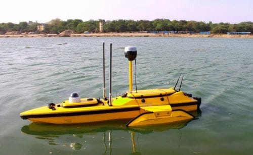
This cutting-edge, remote-controlled equipment allows us to carry out precise bathymetric surveys safely and efficiently. Our hydrographic crews deploy high-tech systems like Teledyne Z-Boats and HyDrone USVs, equipped with multi-beam or single-beam echosounders and positioned using RTK-GNSS for superior accuracy.
For complex projects in locations such as South Delhi, Gurgaon, and Noida, including bridge surveys and nearshore embankment assessments, we also integrate detailed topographic mapping services. Depending on project requirements, our team may utilize sUAS/drones, mobile LiDAR, or terrestrial 3D laser scanners to deliver comprehensive, high-resolution mapping.
As a leading provider of hydrographic survey services in Delhi, Noida, West Delhi, and Gurgaon, we ensure customized, reliable, and technologically advanced solutions tailored to each client’s unique project needs.